Canada’s population is growing by about 500,000 per year. The new residents need housing. Where should these new homes be built?
Readers can probably predict that I’ll recommend letting the market determine the location of the new housing. But let’s suppose you had other goals, beyond market efficiency. Suppose you wished to preserve Canada’s beautiful wilderness areas. In that case, where would you build the housing?
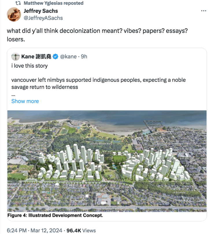
British Columbia is an especially beautiful Canadian province, fully of snow-capped mountains and deep fiords. If the goal were to preserve that wilderness, then the optimal location of new housing would be in existing urban areas—build up, not out. That also happens to be the solution that would be adopted in a free market. And that’s exactly what Canada’s indigenous people have decided to do. They are planning to erect a massive housing development full of high rise buildings right in the city of Vancouver (on native owned land.):

Yes, I get the joke—and it’s kind of funny. And at the risk of being a killjoy, I’d also like to point out that this actually is the “pro-wilderness” solution.
Ronald Coase would not be surprised.


READER COMMENTS
Thomas L Hutcheson
Mar 13 2024 at 6:42am
Or if you were interested in reducing CO2 emissions.
Or attract more high-income earning immigrants.
Or reduce automobile traffic.
NIMBYs will soon become a firm part of the right-wing anti-growth coalition.
BS
Mar 13 2024 at 12:05pm
A large part of what is going to make that development feasible is the light rapid transit extension running west to UBC, which will be along that street at the bottom of the photo (W 10th Ave). Someone else is paying for that, but it will change the character of all of the immediate neighbourhoods. Forests of towers centred on the stations will shortly follow.
There are no high-volume thoroughfares serving that area other than the (barely) two-lanes-each-way street at the bottom of the photo and one along the north edge of the property (W 4th Ave).
The block of land used to be national defence property (pretty much all of the parkland in that photo was) going back to WWII. Negotiating the turnover of the land took decades. The “friends of parks” might have hoped it would stay that way, but I doubt very many informed people (True Scotsmen!) were under the illusion it would not be developed to obtain high profits.
What has got the NIMBYs upset about this development and another one at the south end of the Burrard bridge (lots of towers, way too little proposed parking, interesting experiment) is that the owners aren’t bound by municipal regulations. They need to negotiate utility connections (sewer, water, etc), though – and that’s another interesting experiment, since all of that is getting old and was designed for the volume of use reflecting the nature of the residential blocks you see. There will also be the provision of schools, which if any other growth areas in the greater metropolitan area are templates, will lag the population expansion uncomfortably.
How the right to develop on land under local tribal government interfaces with the privilege of access to necessary infrastructure owned by the surrounding municipality is the experiment they’re running.
Scott Sumner
Mar 13 2024 at 5:34pm
Thanks for that information. I hope they succeed in getting these projects built.
Warren Platts
Mar 20 2024 at 5:13pm
There are two basic ways to deal with pollution: (1) dilute & disperse, or (2) concentrate & contain. Well, there’s also (3) recycle and (4) reusem but if we consider humans to be a form of pollution, (3) and (4) don’t apply since we’re not quite to the Soylent Green stage. Of the first two, concentrate & contain is definitely the best strategy. As evidence consider that the average CO2 emissions per person in New York City is about 6 tonnes per person per year whereas for a resident of Wyoming it’s 94 tonnes per person…
Comments are closed.